Ganges basin climate indicators – Rainfall & Temperature
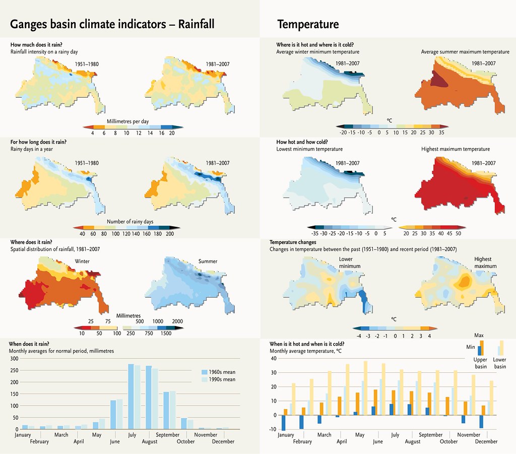
Rainfall: The Ganges basin receives nearly 1,000 mm of precipitation annually. The greatest amount of rain – 84% of the annual total – falls during the monsoon season. Of the remainder, 7% falls during the premonsoon season, 5% in the post-monsoon season, and 4% in winter. There are some differences in precipitation between the upper and lower Ganges basins. Although there is not much difference between the annual amount of precipitation in the lower and upper parts of the basin, the number of rainy days varies considerably. In the upper basin, there are 179 rainy days, whereas in the lower basin there are 152 rainy days. The monsoon season accounts for 75% of the rain in the upper basin and 85% of the rain in the lower basin. For both the upper and lower basins, the number of rainy days is increasing, but the occurrence of rainfall greater than 10 mm/day is decreasing. The monsoon season shows a slight decreasing trend across the basin (although the trend is statistically insignificant, the amount may be significant). There is also an increasing trend in the duration of the monsoon season, with more dry spells within each season. During the winter season, there is an increasing trend in rainfall over most parts of the basin, and a decreasing trend in the central, southwest and extreme north of the basin. Temperature: Over the past decades and across the Ganges basin, winters are getting warmer, but summer average temperatures have remained constant. Summer extremes are becoming more intense, while winter extremes are showing mixed trends across the basin. The average maximum temperature across the basin is 30.3°C in summer and 21.1°C in winter. The average minimum temperature across the basin is 21.5°C in summer and 6.4°C in winter. The premonsoon season is the hottest in the Ganges basin with an average temperature of 31.4°C, with June being the hottest month in the upper basin and May the hottest in the lower basin. The coldest month is January across the whole basin. Over the last decades, there has been no significant trend in terms of changes in maximum temperatures, but there has been an increase in minimum temperatures in every season across the Ganges basin, with as much as a 0.7°C increase in winter minimum temperature. Night-time temperatures are also showing an increasing trend. Extreme high temperatures (highest maximum) are generally increasing across the basin. Extreme low temperatures are rising (getting warmer) in most parts of the basin with more severity over the central part of the basin, while in the northern-most part temperatures are decreasing (getting colder).
Year: 2015
From collection: The Himalayan Climate and Water Atlas
Cartographer: Riccardo Pravettoni