Lake Chad: almost gone
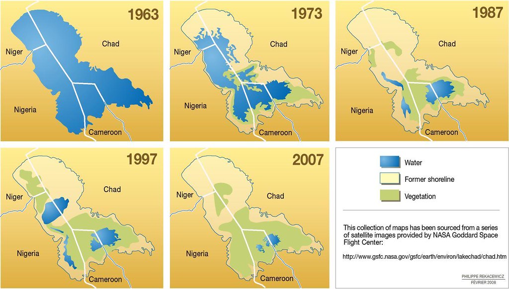
Straddling the borders of Chad, Niger and Cameroon in West Africa, Lake Chad has been a source of freshwater for irrigation projects in each of these countries. Maps drawn from a series of satellite images show a dramatic decrease in the size of the lake over the past 30 years. Since 1963, the lake has shrunk to nearly a twentieth of its original size, due both to climatic changes and to high demands for agricultural water. Since 1963, the surface area of Lake Chad has decreased from approximately 25,000 km2 to 1,350 km2 (Scientific American, 2001). The changes in the lake have contributed to local lack of water, crop failures, livestock deaths, collapsed fisheries, soil salinity, and increasing poverty throughout the region: - Between June 1966 and January 1973, the surface area of Lake Chad shrunk from 22,772 km2 to 15,400 km2. - In 1982, the lake’s surface area was estimated to be about 2,276 km2. In February 1994, Meteosat images measured it at just 1,756 km2. - Between 1953 and 1979, irrigation had only a modest impact on the Lake Chad ecosystem. But between 1983 and 1994 irrigation had increased four-fold. - About 50% of the decrease in the lake’s size since the 1960s is attributed to human water use, with the remainder attributed to shifting climate patterns. - Invasive plant species currently cover about 50% of the remaining surface of Lake Chad. Research carried out over the past 40 years indicates that the main factors in the shrinking of the lake have been: - Major overgrazing in the region (Coe and Foley, 2001), resulting in a loss of vegetation and serious deforestation, contributing to a drier climate. - Large and unsustainable irrigation projects built by Niger, Nigeria, Cameroon and Chad, which have diverted water from both the lake and the Chari and Logone rivers.
Year: 2009
From collection: Vital Water Graphics 2
Cartographer: Philippe Rekacewicz, February 2006