Population density and urban centers in the Mediterranean basin
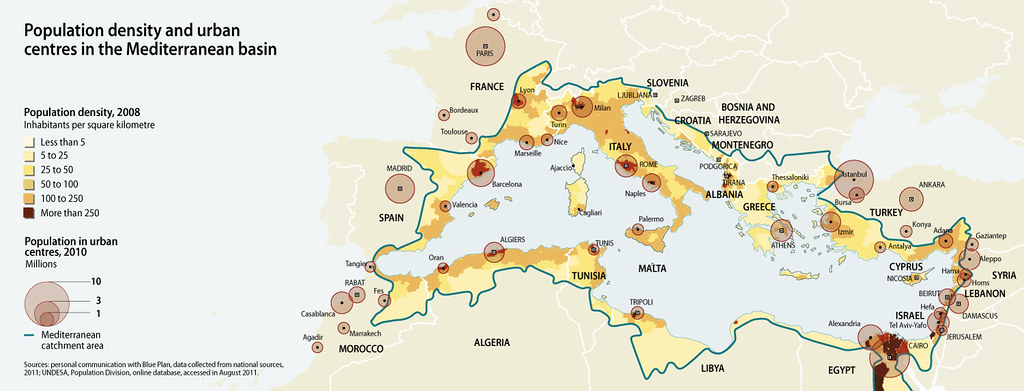
The total population of the Mediterranean countries grew from 276 million in 1970 to 412 million in 2000 (a 1,35% increase per year) and to 466 million in 2010. The population is predicted to reach 529 million by 2025. Four countries account for about 60% of the total population: Turkey (81 million), Egypt (72 million), France (62 million), and Italy (60 million) (Plan Bleu computations based on UNDESA 2011). Overall, more than half the population lives in countries on the southern shores of the Mediterranean, and this proportion is expected to grow to three quarters by 2025 (UNEP/MAP/MED POL 2005). The Mediterranean region’s population is concentrated near the coasts. More than a third live in coastal administrative entities totaling less than 12% of the surface area of the Mediterranean countries. The population of the coastal regions grew from 95 million in 1979 to 143 million in 2000. It could reach 174 million by 2025 (UN/MAP/BP/RAC 2005). The concentration of population in coastal zones is heaviest in the western Mediterranean, the western shore of the Adriatic Sea, the eastern shore of the Aegean-Levantine region, and the Nile Delta. Overall, the concentration of population in the coastal zone is higher in the southern Mediterranean countries. This is also where the variability of the population density in the coastal zone is highest, ranging from more than 1000 people/km2 in the Nile Delta to fewer than 20 people/km2 along parts of coastal Libya.
Year: 2013
From collection: State of the Mediterranean Marine and Coastal Environment
Cartographer: GRID-Arendal